Tropical cyclone Seroja: Three lows menacing waters off WA

[ad_1]
A “rare” event is set to cause havoc on the weekend with as many as three cyclones forming at once plus an unusual and worrying weather phenomenon.
Cyclones, it appears, can be like buses. There are none for ages and then three come along at once
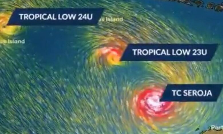
At least that’s the potential in the waters off Western Australia where there is a triple tropical cyclone threat this weekend.
Despite being in the thick of cyclone season, the last one in Australian waters was Niran more than a month ago.
But another concern for forecasters is how the various weather systems might react with one another. There’s a possibility of the rare Fujiwhara Effect taking place where two tropical lows enter the same space.
The Bureau of Meteorology (BOM) has warned of “dangerous weather” in WA with the system on course to head unusually far south.
Warnings are in place for a huge 1000km stretch of the WA coast, partly due to the rare nature of the system making predictions of where landfall could occur exceptionally tricky.
Driving rain, gales force winds and dangerous surf are all on the cards for this weekend. Perth may also see some of the effects of the triple whammy of lows with heavy rain, up to 45mm worth, forecast across the weekend.
RELATED: ‘Polar blast’ could bring coldest day of year so far
Focus on tropical cyclone Seroja
The main focus is on tropical cyclone Seroja, which was named by Indonesia’s meteorological office, the BMKG, because it bubbled up in Indonesian waters.
On Wednesday evening, the category 1 storm was sitting around 700km northwest of Broome travelling southwest at around 24km/h.
Seroja is expected to re-intensify from Thursday to Saturday, to a category 3 storm with winds of up to 157 km/h and gusts peaking at 225km/h, before turning towards the coast on Sunday.
What happens to Seroja will deepened on another tropical low situated around 600km south of Christmas Island, slowly moving south.
It’s called “23U”. Tropical lows only get names when they become fully fledged cyclones. But there’s every chance this low will eventually become cyclone Odette with the Bureau expecting it to intensify to cyclone level as it begins moving east, towards WA.
Then there is a third low, 24U, which is close to the Cocos Islands, and is also heading east and could form into a cyclone.
Right now, 24U is considered to be the least threat to the mainland.
But that’s not the case with Seroja and its growing cousin 23U.
“It’s a dramatic weather event with Seroja moving south-westerly parallel to the north coast of WA and another tropical low close by,” Sky News Weather senior meteorologist Tom Saunders said.
Rare ‘Fujiwhara effect’ could occur
With the two systems so close, the rare Fujiwhara weather phenomenon could occur.
Mr Saunders said this is where the two systems could begin to “dance” with one another.
The Fujiwhara effect is when two lows begin to circle one another almost like they’re sizing each other up. In the southern hemisphere that circling occurs in a clockwise direction.
“What eventually happens is the stronger of the systems can absorb the weaker system so two lows will become one tropical cyclone,” Mr Saunders said.
That outcome isn’t guaranteed; both lows may carry on in their own direction, but one model does have 23U being swallowed whole by Seroja.
If Seroja does absorb 23U, it doesn’t necessarily mean a super cyclone is formed. But it can create havoc with working out how strong the merged system will get and where it will head to next.
Even if the two lows remain separate they can bash each other about, also making it hard to predict which direction they will turn.
‘Unusual’ for cyclones to make landfall so far south
At this point it’s looking like Seroja will make a left hand turn towards land on Sunday or Monday.
The Bureau has said “dangerous weather” is possible from Onslow, south of Karratha, to Jurian Bay, 200km north of Perth, all weekend. Exmouth, Carnarvon and Geraldton are all along this stretch of coast.
“There is the risk of a period of strong winds and rain associated with this system in the Exmouth area on Saturday,” warned the BOM, and that’s even before it’s expected to make impact with land.
If the cyclone does make a beeline for WA, it won’t affect the whole coast – just the area it ends up aiming for.
The region in the cyclone zone could then easily see north of 100mm of rain, enough for flooding, advised Mr Saunders.
The BOM added that if Seroja pushed as far south as some forecasts, towards Geraldton, it would be “unusual” as tropical cyclones rarely cross land south of Carnarvon. The last time that happened was in 2011 with tropical cyclone Bianca.
The BOM has advised people along the coast to keep up to date with the organisation’s latest cyclone warnings.
[ad_2]
Source link


