
[ad_1]
Get set to shiver. Double cold fronts will banish the unseasonably warm weather and see temperatures plunge, bringing hail and snow to parts.
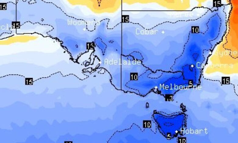
A “polar blast” of Antarctic air is set to sweep across Australia’s south this weekend bringing rain and plunging temperatures.
“A spell of unseasonably warm weather will come to an abrupt end over central and southern Australia this weekend,” said Sky News Weather senior meteorologist Tom Saunders.
The double hit of cold fronts could be so powerful, it may lead to the coldest day of the year so far on Sunday or Monday.
Temperatures could drop so low on Sunday that hail and snow are real possibilities. Melbourne is likely to see its maximum fall from near 30C on Thursday to just 15C on Sunday.
South Australia, southern parts of NSW and the ACT could all feel the chill. Canberra is forecast to hit zero first thing on Sunday morning.
Meanwhile, in Western Australia, a tropical cyclone is approaching the coast with warnings of dangerous and destructive conditions.
The area of high pressure that has led to pleasant skies across the east is shuffling off into the Tasman. In its wake are two separate cold fronts coming in from the Great Australian Bight, sucking north cold air from the polar region.
“The warmer temperatures have left southern Victoria about 5C above average,” said Mr Saunders.
“But the cold front hits Hobart on Thursday night, and on Friday morning cold south westerly winds will arrive in Melbourne.”
The two fronts are also likely to bring bursts of rain.
Getting colder and colder in southern states
In New South Wales, it will remain warm in Sydney for the next couple of days with a high of 30C on Friday and the odd spell of rain.
But the mercury is set to fall with a maximum of 24C on Saturday and then only just getting into the twenties on Monday with a minimum of a mere 11C.
Canberra’s Thursday high of 25C will be distant memory by Sunday when 15C will be the top. The lows will steadily drop from 11C at dawn on Friday to 5C on Saturday and then 0C on a frosty Monday.
Savour Melbourne’s warm Thursday which could reach 29C. Friday will reach 17C, as full 12C cooler, with just 15C on Sunday. Dawn will bottom out at 10C on the weekend. Some showers are likely from Friday until Sunday.
Head inland and those minimums will sink further — a low of just 5C greets Bendigo on Monday morning and just 3C in Wodonga.
The Alps should see snow on the weekend with the mercury hitting -5C.
Across the Bass Strait and it just gets colder still. Hobart’s high of 23C on Thursday will drift down to just 13C on Sunday. Expect a minimum of 8C on Monday morning. Like Melbourne, showers are likely.
Kunanyi/Mount Wellington, towering over Hobart, could bottom out below zero on Sunday with a dusting of snow over the weekend.
In the Tasmanian Highlands the snow could be far thicker, with 20cm of precipitation possible on Saturday alone at Lake St Clair.
It will be milder in Adelaide but temperatures are still set to fall from 31C on Thursday to 19C on Sunday.
Cyclone concerns in Western Australia
On the other side of the Nullarbor, Perth is more settled in terms of heat, bouncing around 30C until Monday when a high of 24C is expected.
Rain, some heavy, is a possibility for the WA capital on Sunday and Monday.
That’s likely as a result of Tropical Cyclone Seroja, which is building up strength in the Indian Ocean and is expected to turn towards land over the weekend or early next week.
The Bureau of Meteorology has issued warnings for “dangerous weather” including gale force winds, heavy rain and dangerous surf for the WA coast from south of Geraldton to north of Exmouth.
Steady highs of 33C in Darwin with lows of 25C. A possible shower on Friday and Sunday.
Brisbane will see 29-31C across the weekend and into next week with mostly clear skies.
[ad_2]
Source link