
Rugby helped Phoebe heal from domestic violence. Now she’s coaching other women to find strength on and off the field
[ad_1]
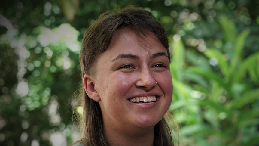
People assume the red scar between Phoebe Caudill’s right eye and nose is an injury from a rugby match.
Table of Contents
Key points:
- Phoebe Caudill says she was abused by a partner in the US
- The incident was reported to police, but no charges have been laid
- To build confidence she started to play rugby and is now kicking goals towards making it to the Super W rugby competition
But the night she got it was no game.
The 25-year-old sees the broken blood vessels under the skin every time she looks in the mirror.
“Every morning when I wake up, I brush my teeth, I look at it and I’m like, ‘alright – this is your day to outlive that little mark’,” she said.
Ms Caudill was allegedly bashed by her then boyfriend as she drove home after a night out in the US. She said he was drunk and accused her of cheating before he attacked her from the passenger seat at a red light.
As the abuse continued along a freeway, Ms Caudill feared she would lose control of the car and potentially kill them both.
She remembers making an excuse that she needed to drive to her home to change her shoes just so she could escape.
“I took it upon myself to say, ‘no, this happens one time, I’m not going to let this happen to me again, I’m not going to fall in that cycle’.”

She ended the relationship and reported the assault to police in the US.
The case is still open and no charges against her ex have been laid.
Coaching female players
A therapist she started seeing after the assault encouraged Ms Caudill to join a contact sport.
She hoped it might rebuild her confidence and help overcome her fear, especially of men.

She thought about lacrosse but couldn’t afford the equipment.
Instead, Ms Caudill chose rugby union because it allowed her to play hard.
“Rugby is a physical sport, it’s a contact sport for women and there’s not many of those out there,” she said.
Within a year she joined a national training academy in America and was then sent to the other side of the world on a development scholarship.
The 25-year-old is now playing for the South Darwin Rugby Women’s side, where she’s well known for her small stature, big personality and long mullet.
Measuring just five-foot tall, Ms Caudill is nicknamed the “honey badger” – she says because she’s small and cute but “dangerous” on the field.
Her passion for rugby has taken her thousands of kilometres from the traffic lights where she was assaulted.
But she has found herself living in the part of Australia with the country’s highest rates of domestic violence.
She brings her experience to the work she does training junior players and as a strength and conditioning coach for female players in the Northern Territory Football League.
Family violence support services:
She wants to empower the players to be strong on and off the field.
“Whether it be in their work, in their home, in their Autism relationships, with their children, anything that they’re going through personally.”
She wants to see her name on a national jumper and will soon be packing up her life again to play for a local club in Perth.
The goal is to one day make selection for the Super W rugby competition.

She occasionally has nightmares of being bashed and still flinches if someone raises a hand.
But she says she’s “an open book”, and happy for her scar to open conversations about intimate partner violence and life afterwards.
“You show him. You show him that you are better than what he gave you — and that’s what I am going to do.”
[ad_2]