
[ad_1]
When cyclone will hit land revealed: Tourists are fleeing from travel hot spots in Western Australia as a rare system of three cyclones closes in on the state.
Residents along Western Australia’s coastline have been warned to bunker down and prepare for heavy rain, relentless wind and flash flooding as a tropical cyclone closes in on the coast.
Exmouth locals are expected to feel the impact of Tropical Cyclone Seroja on Saturday evening and it is forecast to make landfall late Sunday or early Monday, likely between Carnarvon and Jurien Bay, the Bureau of Meteorology said.
The Category 1 system is still sitting more than 500km northwest of Exmouth and 770km north northwest of Carnarvon but is gradually shifting southwest.
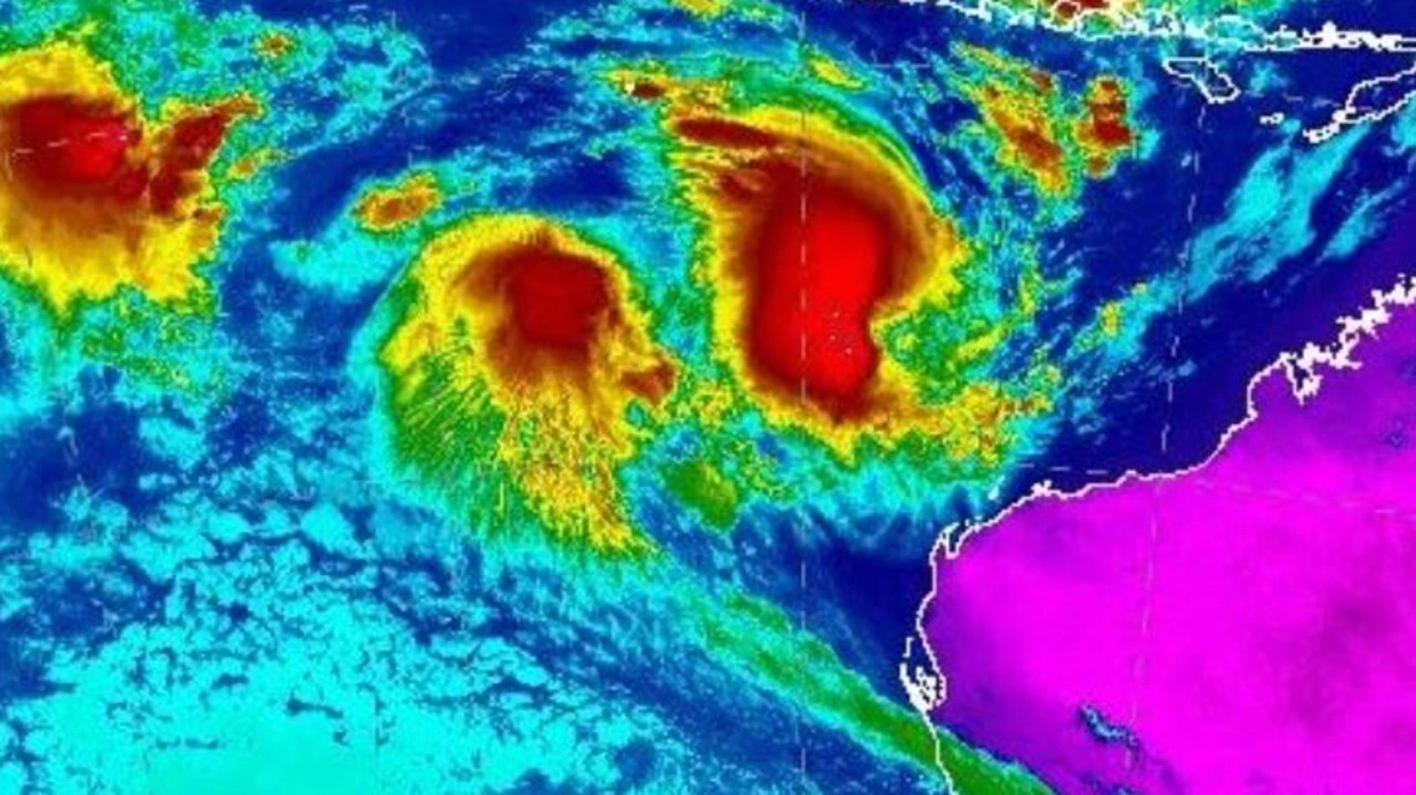
BOM described it as a “rare event”.
“Tropical cyclone Seroja is expected to bring dangerous weather conditions to the west coast during Sunday or Monday … this is a rare event for people on the west coast of Western Australia with potential impacts in the area between Coral Bay and Jurien Bay, including Carnarvon, Denham, Kalbarri and Geraldton,” the bureau said.
But severe weather conditions could also be felt along the south coast, all the way to Perth and even inland into the Wheatbelt and southern Goldfields during Monday.
Earlier, tourists holidaying in Western Australia’s north were warned to leave the area as the state prepared for fierce storms.
People between Onslow and Perth are urged to prepare for tough weather conditions, with dangerous surf and a storm surge making the ocean treacherous, the BOM warned.
“The reason such a large part of Western Australia is expected to be affected is because two tropical systems are expected to approach WA’s coast at different times,” the bureau said in a statement on Thursday.
The first is from a tropical low that could bring heavy rain and gale force winds to the Exmouth area on Saturday night.
If the tropical low intensifies to category 1 by Friday, it will be named Tropical Cyclone Odette.
Late on Sunday or on Monday, Tropical Cyclone Seroja is expected to cross the coast as a category 2 or 3.
It is most likely to bring destructive winds with gusts of about 150km/h and intense rainfall between Carnarvon and Jurien Bay.
Another tropical low is also looming near the Cocos Islands.
BOM senior meteorologist James Ashley said three powerful systems developing at the same time was “extremely uncommon”.
“I’ve been working here in Perth for over 20 years and I’ve never seen us have three systems so close to being cyclones or being cyclones at the one time,” he told reporters.
“Generally, cyclones tend to need a bit of space between them so they don’t mess each other’s inflow and winds and moisture feeds and things like that.”
It is unusual for a tropical cyclone to cross the coast south of Carnarvon, but the bureau has indicated the Fuijiwhara effect, which is the interaction between the tropical low and Tropical Cyclone Seroja, is a factor.
“Cyclones that form in April in the western region typically have a greater chance of moving south out of tropical regions,” the bureau said.
Higher than normal tides are also expected along the west coast.
A significant storm surge is expected closer to where the system tracks and could exceed highest astronomical tide, the bureau added.
[ad_2]
Source link